Thursday, September 22, 2005
Mount Sloan – NE Ridge, With Complications
21 September 2005
[trip report posted to clubtread.com]
Dru and I went to climb Mount Sloan’s NE ridge in summer 2000. We did $900 of damage to the rental 4x4’s running board by mistakenly driving it up the Green Mountain spur instead of up the Ault Creek road. Oops! Upon finally arriving in Ault Creek, we were bombarded by mosquitoes and black flies. The bugs were bad enough that we slept in the back of the car. The next morning, Sloan was scarcely visible through the clouds. We crossed Ault Creek, bushwhacked up to the toe of the ridge through the dripping forest, and had just hit the start of the 3rd class climbing when rain, wind and fog all arrived more or less simultaneously. Back to the car!
I kept looking at pictures of the NE Ridge. Some day…
In late summer 2005, Denis Blair and Ted Oliver did Sloan as a daytrip and posted a nicely illustrated trip report on clubtread.com. A week or two later, I bought dru’s old rusted-out Subaru wagon, and was suddenly mobile again after 15 years without a car. Time for a rematch with the NE Ridge, I told myself. With good weather in the forecast, I drove up to Railroad Pass late on Tuesday night and camped at the Semaphore Lakes trailhead. Uneventful, save for a guy roller blading down the middle of the Whistler-Pemberton highway at 11:15pm.
It froze hard overnight, and I spent a few minutes scraping the car’s windows in the morning. Off at sunrise to Ault Creek. Midway up the access road, I met a 4x4 coming back down. I pulled over to let it by, and the driver stopped and rolled down his window.
“Where ya headed?”
“Sloan.”
“Me too – but I’m not sure if this is the right road or not.”
“Follow me,” I said, “I’ll get you as far as the parking lot.”
Together we drove up the road and into the Ault Creek valley, where the road has been extended several kms. from where it was in 2000. There’s a bridge across the creek, and the road immediately forks, with the left hand branch going almost to the headwall below Lower Ault Lake, and the right fork climbing up onto the toe of the NE Ridge. Parking at the end of the left hand fork makes sense if you are not reversing the ridge climb, because that way you are saved a several km. walk and the corresponding elevation gain to reunite yourself with your car at the end of the day.
“Hey thanks,” said the 4x4 driver. “I’m Chris; what route are you taking?”
“I’m Chris, too. The NE Ridge.”
“Moi aussi. Want some company?”
"Sure, but I’ll probably be a lot slower than you.”
“No worries.”
We packed up and started bushwhacking up toward the NE Ridge overhead. At this point, I had made two mistakes, though I didn’t know it: I hadn’t brought a helmet, which wasn’t the world’s brightest move on a 4th class ridge climb with lots of loose rock, and I left my ice axe in the car, taking only my trekking poles, because only the N face appeared to have snow on it, or so it seemed.
The bushwhack up to the ridge went very smoothly, about an hour of travel through open forest, with lots of mushrooms on the ground. I saw emetic russulas, wooly pine spikes, and some nice looking boletes, as well as lots of others I didn’t recognize. I also threw up several times, and was troubled by a strange ringing sensation in both ears, which I put down to lack of sleep and no coffee.
We reached the ridge and started up toward the start of the technical scrambling. As expected, Chris was anywhere from 20-45 minutes ahead of me all the way to the summit. I threw up again, and was starting to feel pretty dizzy, and concluded that I was coming down with the flu. However, turning back didn’t seem to make a whole lot of sense; if Chris didn’t see me turn around, I was sure he’d worry about where I’d gotten to, and I didn’t want to freak him out, or to accidentally initiate a search and rescue callout. So I continued up the ridge.
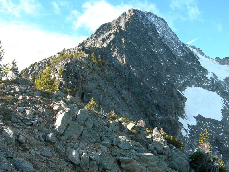
Obstacle 1 is a large gendarme on the ridge which is passed on its left hand side. The route then climbs steeply up toward two huge distinctive rock towers on the ridge. A combination of a steep, dirty gully and a hidden cleft in the right hand side of the right tower made a nice 3rd-4th class route above these obstacles.
The route grows more difficult after the towers. Above them, there is an exposed walk along the ridge crest. The way was now plastered with ice and snow, and I had serious reservations about continuing on the crest, even though Don Funk’s bivouac.com trip report suggested that this was the way to go. Instead I made some funky low 5th-class moves down off the ridge, scrambled along below the crest on the south face, and then back up again and along.
By now I was also shivering, dizzy, and coughing up chunks of yellow phlegm. Not a great combination, and I paid less attention to the view than I would have under normal circumstances. That said, I was pleased with how confidently I was climbing, and with the rock on the ridge, which, when not rimed with snow and ice, was rough and very textured, with an abundance of holds.
The next obstacle was a steep gap just before the summit tower. There were rap slings here, which didn’t exactly fill me with good feelings. Still, the rock looked sound, so I made some more low 5th class moves down into the gap, only to discover, once down, that an easier route exists on the right hand side of the crest, where a hidden ledge system leads easily down to the same point.
I scrambled up the summit tower with Chris peering curiously down from above. This was pretty hard, because by now there was snow and ice everywhere, and the rock was slippery and dangerous. I tried to ascend the north side of the tower, and got stuck about three quarters of the way up on narrow ice-covered ledges. By this point I was pretty gripped, and not having too great of a time. “Think,” I berated myself. “Don’t be an idiot. Look for the easiest way up.” In this case, the “easiest way” involved downclimbing about thirty feet, then contouring around on a series of ledges to the south face, where a staircase of blocks stretched up to the big summit block.
“Good job there,” said Chris.
We only stayed on the summit about ten minutes, then bailed down the south face into a large gully directly below the summit tower. This gave a quick 3rd class descent, but was very loose, and we travelled a ways apart so as to avoid knocking stones down on each other. There are several nasty short walls in the upper end of the gully; in each case, we traversed east to reach easier ground before continuing down. Soon the snow and ice gave way to scree and a small stream, running easily over water-polished ledges. The stream bed steepens near its base, and we passed these bluffs via a ledge system on the right hand side.
We then hiked easily down a moraine to reach the sandy, pumice-covered shore of the upper Ault Lake. This area, with its sand dunes, huge boulders, and peaceful, fluorescent-blue lake, is one of the prettiest places I’ve seen this year.
We easily traversed the east shore of the lake, then scrambled down beside its outlet stream, eventually crossing to the west bank, where we soon picked up a flagged trail. This trail follows the west bank of the creek all the way to the lower Ault lake. Recent trail work has taken out many small trees and deadfall, but there is still some work to be done to pare back the blueberry bushes and shrubs that lean in from every side. The trail skirts the west bank of the lower lake, first gaining elevation, and then dropping back to shoreline near the lake’s east end.
From there, the by now not terribly well laid out trail inexplicably gains more elevation, before dropping steadily into the Ault Creek valley, eventually entering open forest just opposite the end of the clearcut.
At this point, with both knees about to give out, I bushwhacked down to the creek, scrambled across, and clambered up the opposite bank to reach the car. Chris and I chatted, then climbed into our vehicles and went our separate ways. The drive home was uneventful; dinner was coffee and a terrific green salad from the Pony in Pemberton: greens, peaches, black olives, onions, garlic, raspberry vinagrette and some other stuff. $4.50 with a tasty roll; a great deal, and a nice end to a taxing but enjoyable day out in the mountains.

Archives
03/01/2004 - 04/01/2004
04/01/2004 - 05/01/2004
05/01/2004 - 06/01/2004
06/01/2004 - 07/01/2004
07/01/2004 - 08/01/2004
08/01/2004 - 09/01/2004
09/01/2004 - 10/01/2004
10/01/2004 - 11/01/2004
11/01/2004 - 12/01/2004
12/01/2004 - 01/01/2005
01/01/2005 - 02/01/2005
02/01/2005 - 03/01/2005
03/01/2005 - 04/01/2005
04/01/2005 - 05/01/2005
05/01/2005 - 06/01/2005
06/01/2005 - 07/01/2005
07/01/2005 - 08/01/2005
08/01/2005 - 09/01/2005
09/01/2005 - 10/01/2005
10/01/2005 - 11/01/2005
11/01/2005 - 12/01/2005
12/01/2005 - 01/01/2006
01/01/2006 - 02/01/2006
02/01/2006 - 03/01/2006
03/01/2006 - 04/01/2006
04/01/2006 - 05/01/2006
05/01/2006 - 06/01/2006
06/01/2006 - 07/01/2006
07/01/2006 - 08/01/2006
08/01/2006 - 09/01/2006
09/01/2006 - 10/01/2006
10/01/2006 - 11/01/2006
11/01/2006 - 12/01/2006
12/01/2006 - 01/01/2007
01/01/2007 - 02/01/2007
02/01/2007 - 03/01/2007
03/01/2007 - 04/01/2007
04/01/2007 - 05/01/2007
05/01/2007 - 06/01/2007
06/01/2007 - 07/01/2007
07/01/2007 - 08/01/2007
08/01/2007 - 09/01/2007
09/01/2007 - 10/01/2007
10/01/2007 - 11/01/2007
11/01/2007 - 12/01/2007
12/01/2007 - 01/01/2008
01/01/2008 - 02/01/2008
02/01/2008 - 03/01/2008
03/01/2008 - 04/01/2008
04/01/2008 - 05/01/2008
05/01/2008 - 06/01/2008
06/01/2008 - 07/01/2008
07/01/2008 - 08/01/2008
08/01/2008 - 09/01/2008
09/01/2008 - 10/01/2008
10/01/2008 - 11/01/2008
11/01/2008 - 12/01/2008
12/01/2008 - 01/01/2009
01/01/2009 - 02/01/2009
02/01/2009 - 03/01/2009
03/01/2009 - 04/01/2009
04/01/2009 - 05/01/2009
05/01/2009 - 06/01/2009
06/01/2009 - 07/01/2009
07/01/2009 - 08/01/2009
08/01/2009 - 09/01/2009
09/01/2009 - 10/01/2009
10/01/2009 - 11/01/2009
11/01/2009 - 12/01/2009
12/01/2009 - 01/01/2010
01/01/2010 - 02/01/2010
02/01/2010 - 03/01/2010
03/01/2010 - 04/01/2010
04/01/2010 - 05/01/2010
05/01/2010 - 06/01/2010
06/01/2010 - 07/01/2010
07/01/2010 - 08/01/2010
08/01/2010 - 09/01/2010
09/01/2010 - 10/01/2010
10/01/2010 - 11/01/2010
11/01/2010 - 12/01/2010
12/01/2010 - 01/01/2011
01/01/2011 - 02/01/2011
02/01/2011 - 03/01/2011
03/01/2011 - 04/01/2011
04/01/2011 - 05/01/2011
05/01/2011 - 06/01/2011
06/01/2011 - 07/01/2011
07/01/2011 - 08/01/2011
08/01/2011 - 09/01/2011
09/01/2011 - 10/01/2011
10/01/2011 - 11/01/2011
11/01/2011 - 12/01/2011
12/01/2011 - 01/01/2012
01/01/2012 - 02/01/2012
02/01/2012 - 03/01/2012
03/01/2012 - 04/01/2012
04/01/2012 - 05/01/2012
05/01/2012 - 06/01/2012
06/01/2012 - 07/01/2012
07/01/2012 - 08/01/2012
08/01/2012 - 09/01/2012
09/01/2012 - 10/01/2012
10/01/2012 - 11/01/2012
11/01/2012 - 12/01/2012
12/01/2012 - 01/01/2013
01/01/2013 - 02/01/2013
02/01/2013 - 03/01/2013
03/01/2013 - 04/01/2013
04/01/2013 - 05/01/2013
05/01/2013 - 06/01/2013
06/01/2013 - 07/01/2013
07/01/2013 - 08/01/2013
08/01/2013 - 09/01/2013
09/01/2013 - 10/01/2013
10/01/2013 - 11/01/2013
11/01/2013 - 12/01/2013
12/01/2013 - 01/01/2014
01/01/2014 - 02/01/2014
02/01/2014 - 03/01/2014
03/01/2014 - 04/01/2014
04/01/2014 - 05/01/2014
05/01/2014 - 06/01/2014
06/01/2014 - 07/01/2014
07/01/2014 - 08/01/2014
08/01/2014 - 09/01/2014
09/01/2014 - 10/01/2014
10/01/2014 - 11/01/2014
11/01/2014 - 12/01/2014
12/01/2014 - 01/01/2015
01/01/2015 - 02/01/2015
02/01/2015 - 03/01/2015
03/01/2015 - 04/01/2015
04/01/2015 - 05/01/2015
05/01/2015 - 06/01/2015
06/01/2015 - 07/01/2015
07/01/2015 - 08/01/2015
08/01/2015 - 09/01/2015
09/01/2015 - 10/01/2015
10/01/2015 - 11/01/2015
11/01/2015 - 12/01/2015
12/01/2015 - 01/01/2016
01/01/2016 - 02/01/2016
02/01/2016 - 03/01/2016
03/01/2016 - 04/01/2016
04/01/2016 - 05/01/2016
05/01/2016 - 06/01/2016
06/01/2016 - 07/01/2016
07/01/2016 - 08/01/2016
08/01/2016 - 09/01/2016
09/01/2016 - 10/01/2016
10/01/2016 - 11/01/2016
11/01/2016 - 12/01/2016
12/01/2016 - 01/01/2017
01/01/2017 - 02/01/2017
02/01/2017 - 03/01/2017
03/01/2017 - 04/01/2017
04/01/2017 - 05/01/2017
05/01/2017 - 06/01/2017
06/01/2017 - 07/01/2017
07/01/2017 - 08/01/2017
08/01/2017 - 09/01/2017
09/01/2017 - 10/01/2017
10/01/2017 - 11/01/2017
11/01/2017 - 12/01/2017
12/01/2017 - 01/01/2018
01/01/2018 - 02/01/2018
02/01/2018 - 03/01/2018
03/01/2018 - 04/01/2018
04/01/2018 - 05/01/2018
05/01/2018 - 06/01/2018
06/01/2018 - 07/01/2018
07/01/2018 - 08/01/2018
08/01/2018 - 09/01/2018
09/01/2018 - 10/01/2018
10/01/2018 - 11/01/2018
11/01/2018 - 12/01/2018
12/01/2018 - 01/01/2019
01/01/2019 - 02/01/2019
02/01/2019 - 03/01/2019
03/01/2019 - 04/01/2019
04/01/2019 - 05/01/2019
05/01/2019 - 06/01/2019
06/01/2019 - 07/01/2019
07/01/2019 - 08/01/2019
08/01/2019 - 09/01/2019
09/01/2019 - 10/01/2019
10/01/2019 - 11/01/2019
11/01/2019 - 12/01/2019
12/01/2019 - 01/01/2020
01/01/2020 - 02/01/2020
02/01/2020 - 03/01/2020
03/01/2020 - 04/01/2020
04/01/2020 - 05/01/2020
05/01/2020 - 06/01/2020
06/01/2020 - 07/01/2020
07/01/2020 - 08/01/2020
08/01/2020 - 09/01/2020
09/01/2020 - 10/01/2020
10/01/2020 - 11/01/2020
11/01/2020 - 12/01/2020
12/01/2020 - 01/01/2021
01/01/2021 - 02/01/2021
02/01/2021 - 03/01/2021
03/01/2021 - 04/01/2021
04/01/2021 - 05/01/2021
05/01/2021 - 06/01/2021
06/01/2021 - 07/01/2021
07/01/2021 - 08/01/2021
08/01/2021 - 09/01/2021
09/01/2021 - 10/01/2021
10/01/2021 - 11/01/2021
11/01/2021 - 12/01/2021
12/01/2021 - 01/01/2022
01/01/2022 - 02/01/2022
02/01/2022 - 03/01/2022
05/01/2022 - 06/01/2022
06/01/2022 - 07/01/2022
12/01/2022 - 01/01/2023
01/01/2023 - 02/01/2023
03/01/2023 - 04/01/2023
05/01/2023 - 06/01/2023
08/01/2023 - 09/01/2023
11/01/2023 - 12/01/2023
04/01/2024 - 05/01/2024
05/01/2024 - 06/01/2024